OpTIS: Operational Tillage Information System
Please note that the OpTIS Team has created a new company called Dagan to provide data services to the soil health community. Please email optis@daganinc.com or visit our website daganinc.com to learn more.
Applied GeoSolutions has developed a system for operational mapping of tillage practices and cover crops over wide areas. The system, called the Operational Tillage Information System or OpTIS, produces spatially comprehensive maps of crop residue cover and cover crops annually using information integrated from multiple earth-observing satellites. Accurate, timely, and spatially comprehensive information about the dynamic state of tillage practices and cover crops across large regions is valuable for several purposes. For example, regional and national agricultural offices use this information to evaluate and compare the effectiveness of conservation programs (as measured by the adoption of conservation tillage) across large regions. These groups can use this information to identify areas with low rates of conservation technology adoption and target these areas for future support. Environmental research groups at universities use spatial information on conservation practices for modeling water quality and the carbon cycle. Recently, collaborative groups have joined together to implement water quality trading programs designed to efficiently reduce nutrient loads entering the waterway. The maps developed through the OpTIS system provide the spatially targeted and comprehensive information required by these markets.
OpTIS relies on observations from multiple satellite sensors, in combination with information on soil moisture, to produce sub-farm field estimates of crop residue cover and winter crops. For most applications, including our pilot project in Indiana, these sub-farm field estimates are summarized at the county or watershed level to provide the detailed information needed for a particular application while protecting producer privacy.
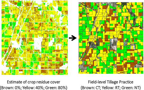
Figure 1. Illustration of the generation of tillage products for a region in the mid-western USA.
In a collaborative effort with the Conservation Technology Information Center (CTIC), Applied GeoSolutions has implemented the OpTIS system to estimate crop residue cover and cover crops across the state of Indiana between 2006 and 2015. This pilot project, funded as a collaborative public-private partnership, was recently completed. The outcomes of the pilot project include county and watershed level maps of conservation tillage and cover cropping at an annual time step, as well as a comprehensive report outlining the performance of the system.
Funding for the OpTIS Indiana Pilot Project was provided by: USDA Climate Change Program Office (CCPO), Howard G. Buffett Foundation, Monsanto, John Deere, Soil Health Partnership, Indiana Soybean Alliance, and Indiana Corn Marketing Council.
If you have any questions about OpTIS or the Indiana pilot project, please contact Stephen Hagen (Dagan; shagen@daganinc.com) or Mike Smith (CTIC; smith@ctic.org).